Anyone reading this far who has ever
lived,
bought a home, gardened, or dug a hole in the Laytonsville area
would
say:
"Stone mason? Where did he get the rocks?"
Look at
the
names of communities in the Laytonsville area -- Red_land,
Clays_ville.
The area has a layer of topsoil over a solid, deep layer of red
clay.
It is great for bricks and almost becomes one giant underground
brick
in
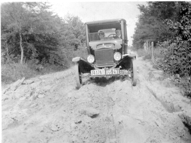
a really dry summer. Before Rt. 108 was paved, it looked
like
this
(see below) in spring or after a rain.
|
Dwyers driving on the Laytonsville road. Notice the double license tags. You used to need a tag for driving in Maryland and an additional tag for driving in the District of Columbia. |
Some great ruts and mud lumps there. But no rocks. So where were the rocks? What masonry?
The local ground does contain a fieldstone which could be quarried and used for lining basement walls, foundations, and wells and for attempts to mend potholes in the old dirt roads.
This is a really interesting area in which to dig a well.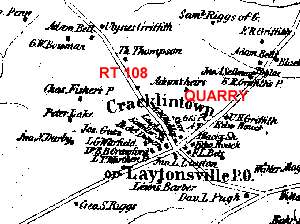 |
The Laytonsville quarry was
northeast
of the crossroads. In the winter the same area,
flooded and
frozen
over, was used for cutting ice for icehouses.
This is the 1865 Montgomery County map. Notice the Layton House (still there on the SW corner) and Richard Dwyer across the street in the old brick tavern (long gone, along with the saddlers shop). |
Home
Please send comments and corrections to Webmaster@wolffmad.com
Copyright © 2013 Anne Wolf, All rights reserved