|
Record 5/7 |
|
Description
|
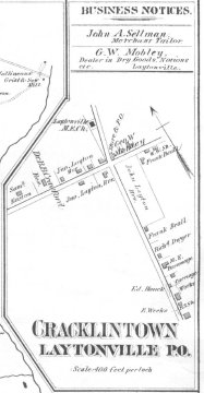
| 1879 map of Cracklintown/Laytonsville area showing the intersection of present-day Rt. 108 and Brink Road |
Detailed map of the town in 1879
-History of the Town of Laytonsville
COPYRIGHT INFORMATION ~ When using this image, the credit line should be in the following format: Image courtesy of the Laytonsville Historical Center, Inc.
| G.M. Hopkins map of 1879 - Cracklintown/Laytonsville |
COPYRIGHT INFORMATION ~ When using this image, the credit line should be in the following format: Image courtesy of the Laytonsville Historical Center, Inc.