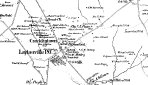
1865 Martinet & Bond Map of Cracklintown-Laytonsville
|
|
|
|
|
| Description |
Section of the 1865 Martinet and Bond's Map of Montgomery County featuring the roads and residents of the Cracklintown/Laytonsville area |
| Object ID |
2009.4.8 |
| Object Name |
Map |
| Title |
1865 Martinet & Bond Map of Cracklintown-Laytonsville |
|
|
COPYRIGHT INFORMATION ~ When using this image, the credit line should be in the following format: Image courtesy of the Laytonsville Historical Center, Inc.
|
|
|
Laytonsville Historical Center, P.O. Box 5158, Laytonsville, MD 20882
HistoricLaytonsville@gmail.com
Last modified on: December 14, 2009
|